Munros Tables SMC Ben Lawyers & Glen Lyon OS Map

 The Scottish Highlands


Creag MacRanaich
The High Mountains of Britain & Ireland Southern Highlands - Map

Photographs of an ascent of the Corbett Creag MacRanaich

 above Glen Ogle


Meall nan Tarmachan from Creag MacRanaich

Meall nan Tarmachan

from Creag MacRanaich


Ben Lawyers above Killin and Loch Tay

Ben Lawyers above Killin

 and Loch Tay

 
from Creag MacRanaich


Stob Binnein and Ben More from Creag MacRanaich

Stob Binnein and Ben More

from Creag MacRanaich


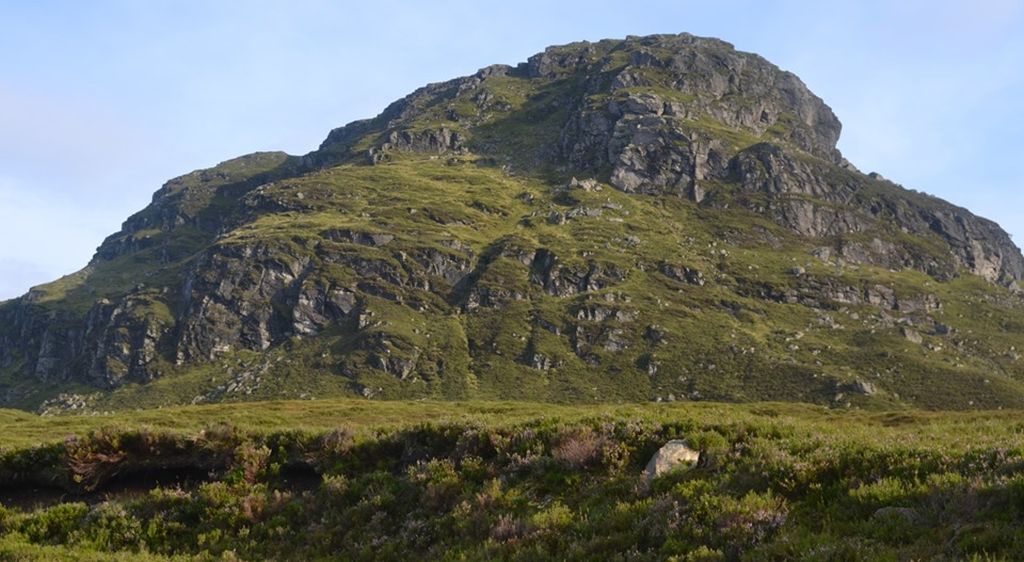
Summit of Creag MacRanaich

Summit of Creag MacRanaich ( 2654ft )


Summit of Creag MacRanaich

Summit of Creag MacRanaich ( 2654ft )


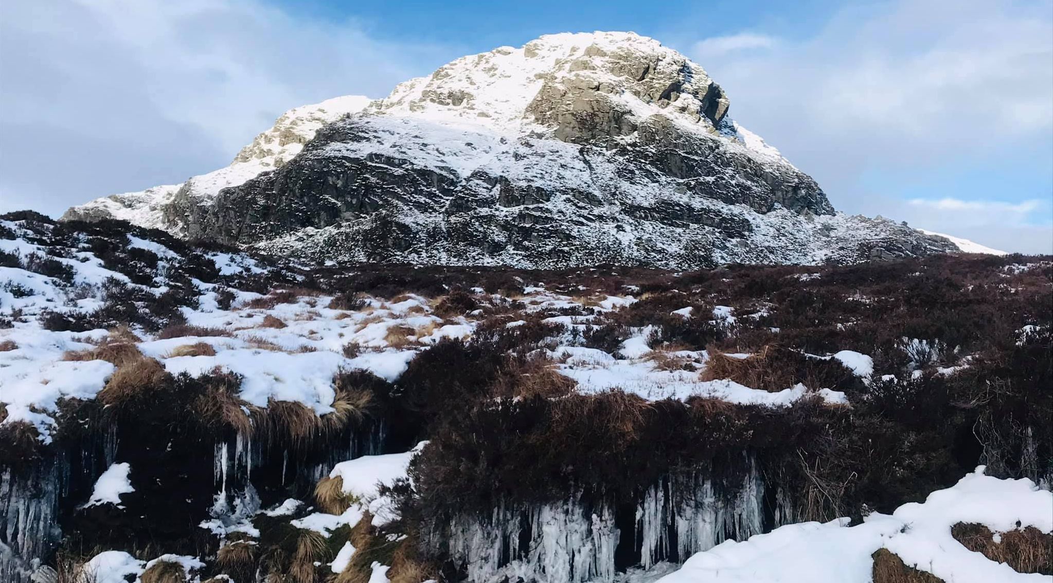
Summit of Creag MacRanaich in winter

Summit of Creag MacRanaich

 in winter


Ben Vorlich and Stuc a Chroin from summit of Creag MacRanaich

Ben Vorlich and Stuc a Chroin

from summit of Creag MacRanaich


Meall nan Tarmachan and Ben Lawyers on descent from Creag MacRanaich

Meall nan Tarmachan and Ben Lawyers

above Loch Tay

on descent to Glen Ogle

 from Creag MacRanaich


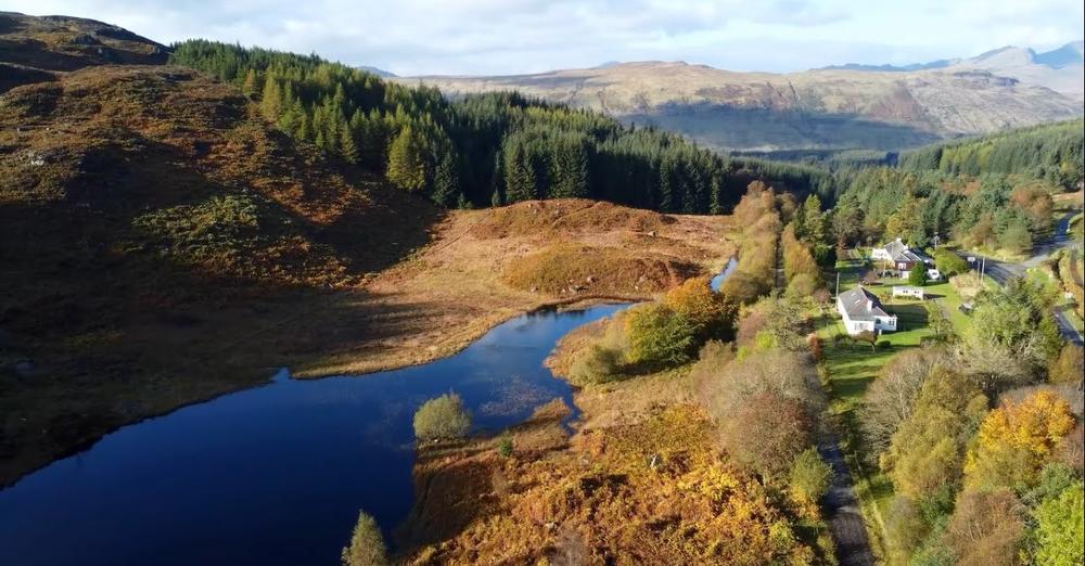
Glen Ogle above Lochearnhead

Glen Ogle above Lochearnhead


Glen Ogle above Lochearnhead

Glen Ogle above Lochearnhead


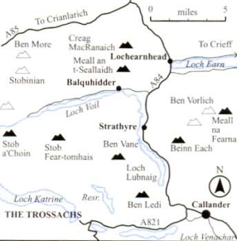
Location Map for Creag Macranaich

Location Map for Creag MacRanaich


Location Map for Creag Macranaich

Location Map for Creag Macranaich


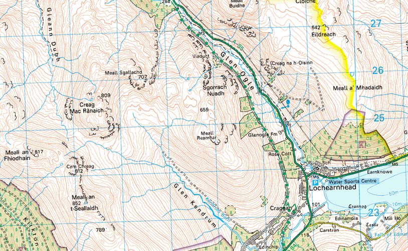
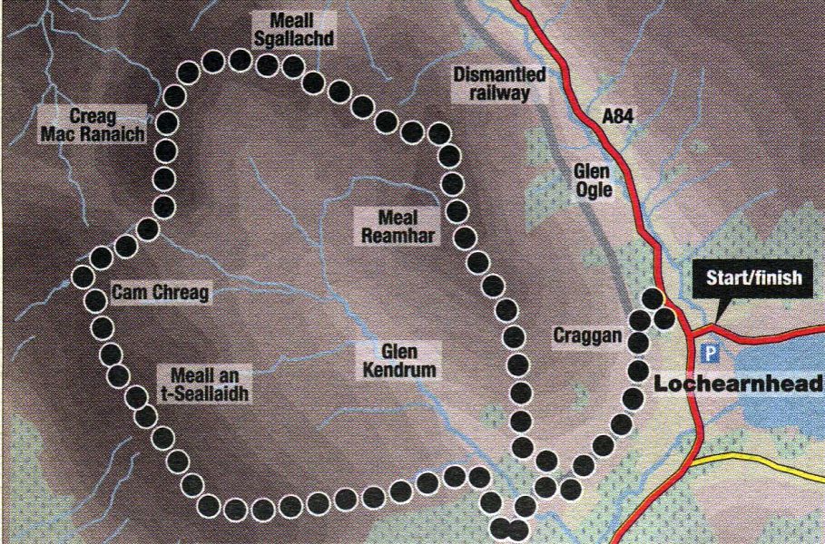
Route Description and Map for Creag Macranaich

Route Map for Creag Macranaich

 and Meall an t-Seallaidh


MEALL an t-SEALLAIDH and CREAG MACRANAICH - ROUTE DESCRIPTION:

Location: Lochearnhead, Stirlingshire
Map: OS Landranger 51 ( GR542234 )
Distance: 11 miles ( 18km )
Time: 6 hours 30 minutes
Terrain: tracks and open hillside


The high ground between Lochearnhead and Balquhidder is dominated by two corbetts, Meall an t-Seallaidh and its near neighbour Creag Mac Ranaich.
The former is the higher and bulkier of the two, but the latter is rockier and more interesting.
Both hills are easily climbed from the high point on the vehicle track up Glen Klendrum which divides them, but this is a dull route for summit-tickers in a hurry.
Hillwalkers wanting a bit more exercise and mountain environment can combine the two peaks into a longer and more interesting round.
Park at the large car park on the A85 at the eastern end of Lochearnhead and walk west to the village centre. Cross over and turn right towards Glen Ogle, to
reach Lochearnhead Scout Station at the north end of the village and a sign for the Glen Ogle Trail, and ascend the path to the line of the old railway.
Cross the old railway line and straight up to a rickety gate in the deer fence. Go through this with care and ascend the hillside - which has extensive views over Loch Earn
- to gain a fence, which in turn leads to the top of craggy Meall Reamhar and views north to Meall nan Tarmachan and Ben Lawers.
Creag Mac Ranaich’s craggy corrie lies ahead and slightly west, but a more circumspect line needs to be taken to avoid the worst of the peat hags and boggy ground.
Sticking as much as possible to the high ground, follow the old fence line round and through a boggy section to firmer ( if rougher ) ground to arrive at Meall Sgallachd, Mac Ranaich’s eastern nose.
Skirt the rocky front of Meall Sgallachd to the east and north to gain a small cairn on the top, from where a broader undulating ridge with views north-west to Stob Binnein and Ben More leads to the
top of Creag Mac Ranaich.
From the summit, follow fence posts, then steep grass, down past crags to the Glen Klendrum track.
Cross over and ascend the slope beyond to gain the broad ridge north of Cam Chreag; pass over this to the summit of Meall an t-Seallaidh.
Descend the broad south-east ridge to near its end, then follow the forest edge down into Glen Klendrum to a track which leads through the forest to a field.
Cross the field to the far right-hand corner where a gate gives access to the old railway, and follow this left.
Keep left at the next junction, passing under two bridges to arrive back at the Glen Ogle Trail path down to Lochearnhead.
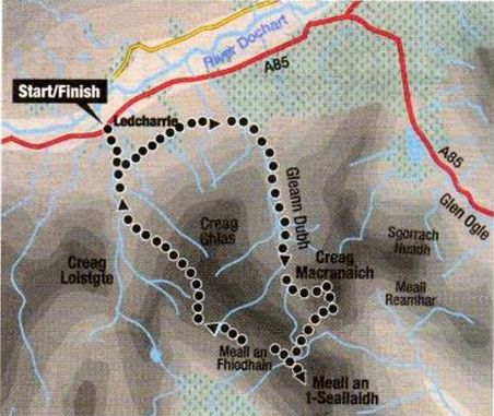


Route Map for Meall an t-Seallaidh and Creag Macranaich

Route Map

 for 
Meall an t-Seallaidh

and Creag Macranaich


MEALL an t-SEALLAIDH and CREAG MACRANAICH - ROUTE DESCRIPTION 2:


Location: Stirlingshire
Map: OS Landranger 51
Distance: 12 miles ( 20km )
Time: 6-8 hours
Terrain: Serious hill walk

The two Corbetts of Meall an t-Scallaidh and Creag MacRanaich dominate the high hinterland of the Braes o’ Balquhidder. This route takes you onto the long ridge between Meall an Fhiodhain and Meall an t-Seallaidh from the glen. From the ridge you can drop down to the bealach between the latter and its neighbour, Creag MacRanaich, and then scramble up through a gap in the crags that girdle MacRanaich's southern flanks. You can then return the same way, to the Meall an t-Seallaidh ridge before dropping back into the Kirkton Glen.
The obvious drawback to this route is that you have to cross the Meall an t~Seallaidh ridge twice.
A possible alternative route from the south leaves Edinchip and follows the length of Glen Kendrurn.
This route climbs up to the high bealach that links the two Corbetts from where both summits can be picked off, although the ascent of the final slopes to Creag MacRanaich’s summit ridge is well protected by black, glistening crags. These crags become less daunting the farther north you walk into Gleann Dubh, but beware — a straightforward ascent through the crags on a day of good visibility can become considerably more daunting in mist or cloud.
To tackle the hills from Glen Dochart, from the Crianlarich / Lix Toll road at Ledcharrie.
Follow a sketchy path from Ledcharrie as far as the old railway line that used to run down Glen Dochart to Crianlarich.
Then follow the trackbed for about three kilometres to the mouth of Gleann Dubh, where another path reaches all the way up to the bealach between the two Corbetts. Creag MacRanaich is then easily picked off from here by taking a careful, and steep, line up grassy slopes between the crags.
Retrace the same route back to the bealach and climb easily onto the Cam Chreag outlier of Meall an t-Seallaidh.
A pleasant stroll gains the view from the summit. The silver slash of Loch Voil forms a foreground to layer upon layer of mountain slopes, and it’s easy to see why this hill is translated as ‘hill of views‘. It is a long and bumpy high-level ridge walk back towards Creag Ghlas above Ledcharrie and the descent back to the Kirkton Glen path.


Creag Macranaich Gallery Photo Gallery

<< BackSouthern Highlands : Next >>


Scotland Index :: Scottish Peaks

Isle of Skye :: Isle of Arran :: West Highland Way

Knoydart :: Glencoe :: Ben Nevis :: NW Highlands :: Eastern Highlands :: Central Highlands


Worldwide Mountaineering :: Adventure Travel :: Site Index

fb icon  google+ icon Linkedin icon  twitter


Guide Books & Maps - Scotland:-


Ben Lawyers & Glen Lyon - OS Explorer Map  Ben Lawyers & Glen Lyon OS Map

Arrochar Alps - Map Glasgow Popular Hills - Map West Highland Way - Map Loch Lomond North - Tyndrum, Crianlarich, Arrochar - OS Explorer Map Loch Lomond and Inverary OS Landranger Map

Isle of Arran OS Explorer Map Isle of Arran OS Landranger Map Arran - Official Tourist MapIona & Mull MapWestern Scotland & the Western Isles OS Road Map Northern Scotland OS Road MapSouthern Scotland OS Road Map


The High Mountains of Britain & Ireland

Munros Tables SMC The Munros - Scotland's Highest Mountains  Scotland - Lonely Planet  NW Highlands - SMC Guide  Exploring the Far NW of Scotland  Guide to Walks in NW Highlands

Walking in Scotland - Lonely Planet Mountain: Exploring Britain's High Places  National 3 Peaks Walk Scottish Highlands Hillwalking Guide The Scottish Islands Bouldering in Scotland

Central Highlands: Six Long Distance Walks West Highland Way: Official GuideWest Highland Way: Rucksac ReadersWest Highland Way: TrailblazerThe West Highland WayWest Highland Way: Footprint MapWest Highland Way - Map West Highland Way - Map 100 Hillwalks around Glasgow

Pathfinder Guide: Fort William and Glen Coe Walks Rambler's Guide: Ben Nevis and Glen CoeGlencoe Rock & Ice Climbing The Munros: Scottish Mountaineering Club The Munros and Tops The Corbetts - SMC Munros & Corbetts Chart The High Mountains of Britain and Ireland Munro Almanac

The Munros - Scotland's highest mountains Call of the Corbetts Magic of the Munros Hamish's Mountain WalkThe Munros in WinterMy Scotland by Hamish MacInnes

Scottish Mountains - 50 Classic Routes50 More Routes on Scottish Mountains The High Mountains of Britain and Ireland Scotlands 100 Best Walks Scottish Mountains - 100 Best RoutesBig Walks of Great Britain Classic Walks in Britain & Ireland

Scottish Hill & Mountain Names Classic Mountain Scrambles in Scotland Classic Climbs - Central & Southern Highlands Mountaineering in Scotland and Undiscovered Scotland by W.H.MurrayMore Wilderness Walks Wilderness Walks Wilderness Walks 2 - Video Ski Mountaineering in Scotland

Ski Touring in ScotlandScrambles in Lochaber Rock Climbing in Scotland Rock Climbing SkillsThe FACE: Six Great Climbing Adventures Ben Nevis: Rock & Ice ClimbsGreat Snow & Ice Climbs of the British Isles100 Best Routes on Scottish Mountains One Man's Mountains - Tom Patey

A Mountaineer's Tale - W.H.MurrayDougal Haston: Philosophy of RiskThe Glens of Rannoch Southern Highlands - MapNorthern Highlands Central Highlands West Highlands Central Highlands SMCNW Highlands SMC

Scotland - Lonely PlanetScotland's Highlands & Islands - Lonley Planet Scotland's Highlands & Islands - Rough Guide Highlands & Islands of Scotland - Hidden Places Rough Guide ScotlandScottish Highlands & Islands - Rough Guide Rough Guide: Scotland Lonely Planet, Walking in ScotlandLonely Planet - Walking in Britain

50 Walks in the Scottish Highlands & Islands 100 Walks in ScotlandVisit Scotland - Touring Guide Scotland: Where to Stay - Hotels & Guest Houses Scotland: Where to Stay - Bed & Breakfast Hillwalker: The MunrosHillwalker: The Corbetts

Weather for Hillwakers & Climbers Mountain Weather Guide to the Weather Weather: Collins Gem Hillwalking Handbook for Mountain Leaders Hillwalkers Manual Hillwalkers Guide to Mountaineering First Aid on Mountains


Google Analytics


Google Analytics

extremetracking
 eXTReMe Tracker


extremetracking
Sitelock
SiteLock
Sitelock